Groundworks Release Notes 2.0->
If you want newest software version updated to your machine, contact SITECH support +358 20 111 5977.

2.0.23201.330 Q1 2024
Bug fixes
GW-9077 - Report Generator Exporting Empty “Drilled lengths” CSV and TXT files - Resolve Exporting drilled lengths as part of Report Generator works as intended, editing drilled lengths is reflected in reports/report generator, and reports are appropriately updated after each hole drilled.
GW-9018 - Groundworks Activating/Deactivating Surface Results in Cut/Fill Info bar - Resolved: Now when users deactivate a surface (with no other surface set to active) they will see the infobar Cut/Fill go to "Fill (Surface) = 0". However, as soon as the surface is reactivated it returns to "Cut (Surface)" equal to the corresponding distance to the surface.
GW-9101 - Disable internal calibration offset when not using TS900 sensor- Vermeer PD1 machines use the onboard sensor for mast angle reported into Groundworks via the OEM integration. If the machine was previously calibrated using TS900, this fix resolves any conf caused by residual calibration values from the TS900.
GW-9084 - Drill Data through TCC - As-built information synched with TCC in IREDES Folder now includes only a single as-built quality xml file for all hole
GW-9014 -Infobar was blank for all GNSS information in .296 - Resolved: There are now live values for GNSS information shown in the Infobar.
New Features
GW-9036 - Inverting Bullseye Navigation Arrows for Vermeer PD10 - A toggle has been added that inverts the direction of the navigation arrows that are viewed when looking at either the Bullseye View or Bullseye Overlay.
GW-9088 - Cannot log exploratory drill hole - Toggling Off "Single Hole" in Exploratory Hole Me deselects the existing drill plan and allows users to log multiple holes by just hitting the Record button.
v2.0.23201.294 Q4 2023
NEW FEATURES:
Add design
Starting from Groundworks v2.0, design and drill/pile plans will no longer have to be separated but can be contained in one single VCL file.
Supported File types
- VCL - Trimble proprietary file from Trimble Business Center
- .xml - IREDES standard files from other software
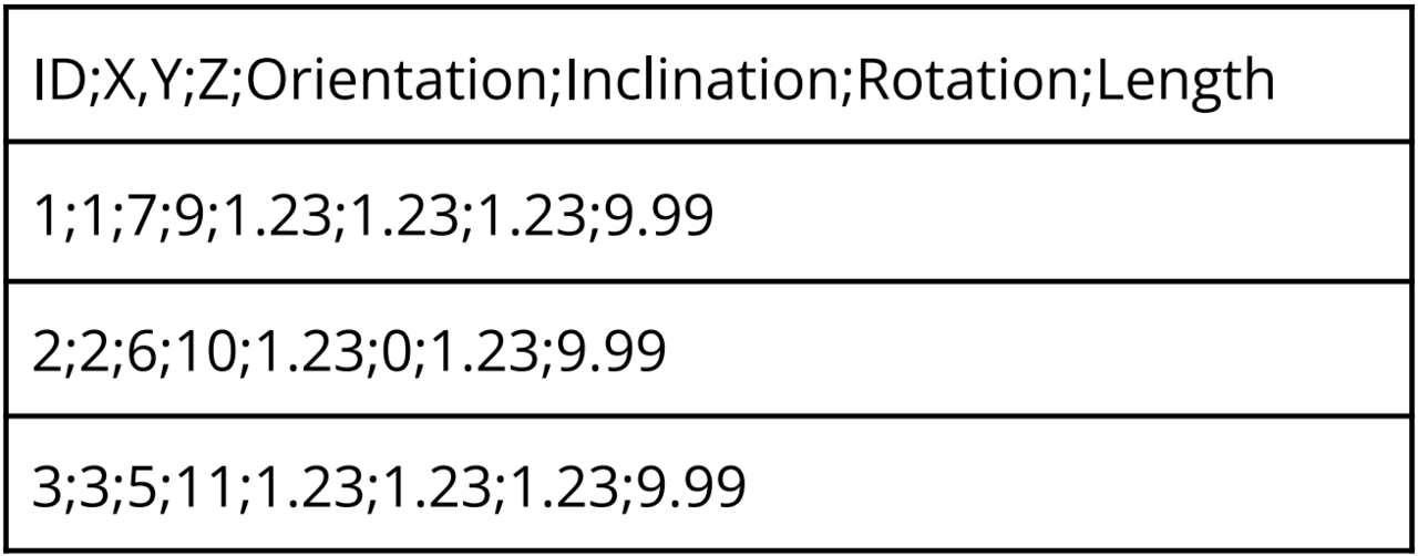
- .CSV - must follow the following guideline
CSV Direct Import
From the Project Setup Window in Groundworks, users have the option to import a standard VCL, LandXML, or a CSV file. The CSV must adhere to a specific format to import successfully into Groundworks. See excer from the Groundworks v2.0 Software Configuration Guide.

As a first step, from the example, all items in red must be deleted. Next open the CSV wi Notepad select the EDIT tab and select all, which will highlight everything. Then on the same EDIT tab hit the REPLACE option, delete the entry in the “FIND WHAT” box and input a (,)comma then in the “REPLACE WITH” box add a (;) semicolon. Finally, choose the “REPLACE ALL” button and to replace all the commas with a semicolon. Hit the save and exit, now you should be able to import the CSV design into Groundworks.
In the example the pile ID and color has also been added, but you can add other columns as well to include orientation, inclination or rotation (all in degrees).
